Back to Essential Guide to Precision Farming Tools
DJI — Agras MG-1
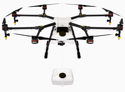
Tech Specs: For the first time in North America, DJI unveiled its first agriculture-specific unmanned aerial vehicle, the Agras MG-1. Designed for fertilizer application, the octocopter unit features a 2.5 gallon tank and can spray 7-10 acres per hour.

WOW Factor: The system has a terrain-following radar, which allows for spraying at a consistent altitude above crops, along with adjustable spray nozzles to apply from the side or on top of the crop.
SENSEFLY — eBee SQ
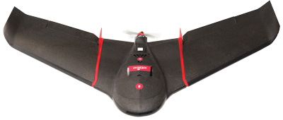
Tech Specs: The new eBee SQ from senseFly combines the benefits of precise crop imaging with large ground coverage, and is fully compatible with existing agricultural workflows. The UAV can cover hundreds of acres in a single flight — up to 10 times more ground than quadcopter drones — for efficient crop monitoring and analysis. The system fully integrates Parrot’s Sequoia camera, a multispectral sensor that captures data across four highly distinct spectral bands (near-infrared, red-edge, red and green) plus visible RGB imagery — in one flight. Once the drone’s images have been processed, the broad spectral data enables numerous vegetation indices to be computed. The resulting index maps can then be employed to assess factors such as a plant’s chlorophyll levels, a key indicator of crop health.
WOW Factor: The ag drone can fly for up to 55 minutes on a single battery charge, enabling it to cover up to 500 acres in a single flight at 400 feet above ground level for extremely efficient crop monitoring and analysis. The result is fewer flights per project, for less time spent collecting data and more time acting on it.
AGCO — Solo AGCO Edition
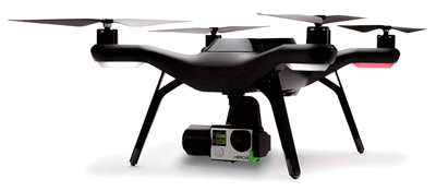
Tech Specs: The Solo AGCO Edition UAV utilizes mission planning and cloud-based, high-resolution mapping software to capture NDVI imagery and field health mapping. The system utilizes Agribotix imaging and analysis software and had 2 customized cameras with specialized lenses for aerial mapping.
WOW Factor: The quadcopter is capable of up to 20 minutes of flight time with camera and gimbal, has auto take off and landing capabilities and can travel as a maximum speed of 55 miles per hour.
SENTERA — Single Sensor
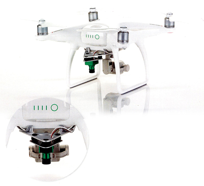
Tech Specs: The new Single Sensor from Sentera can transform the DJI Phantom 4 drone into a precision farming scouting tool, enabling users to capture near-infrared (NIR) imagery and produce normalized difference vegetation index (NDVI) crop maps. Users can also use the built-in camera for video and still imagery. With flight times of up to 28 minutes and a standard optical sensing system, the unit allows users to systematically collect critical, precise crop-health data.
WOW Factor: The system lets users collect NIR and NDVI imagery simultaneously and integrate into the AgVault 2.0 mobile app to organize, store, view and share collected imagery with dealer and other trusted advisors.


Post a comment
Report Abusive Comment