|
Sentera is the leading agriculture data solutions company providing real-time agronomic outcomes. Proven analytic solutions deliver stand count, weed pressure, crop health, elevation, harvest readiness data and more. Sentera’s completely integrated solutions include FieldAgent software, sensors, analytics, unmanned aerial systems (UAS), training, service and ongoing customer support. Sentera’s solutions can be found in over 800 retail locations globally.
Sentera drives ag innovation with a team of science and engineering professionals in remote sensing, data science and data analytics. They’re technical and business leaders with years of experience at Lockheed Martin, UTC Aerospace Systems — Collins Aerospace and other world-class organizations.
Sentera’s FieldAgent Platform is a software that delivers insights derived from machine learning, computer vision and other AI techniques at scale to agronomic professionals around the world. It integrates mobile, web, desktop and cloud components to deliver fast, accurate information, boosting productivity and lowering costs for agronomists and advisors. It also improves outcomes for growers, and drives engagement and adoption for its digital platform partners.
PROPRIETARY TRADE NAMES:
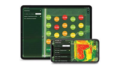
- FieldAgentTM Platform: Sentera’s FieldAgent platform enables you to leverage real-time data to take in-season action. Compatible data layers include drone-sensed, satellite, ground and manned insights.
- PHXTM UAV: Sentera’s PHX UAV is a long-range, robust and fast fixed-wing drone used for crop scouting. The PHX is ideal for scouting large farms or multiple plots.
- TrueNDVI® Sensors: TrueNDVI Sensors derive a plant’s unique reflection using near-infrared (NIR) light, providing users with a superior indication of crop health compared to the naked eye can see and standard RGB sensors.
- LiveNDVI®: Using Sentera’s Double 4K or AGX710 sensor on a PHX or DJI M200 drone, users are able to access LiveNDVI data and livestream NDVI video at the field edge — while their drone is in flight.
ANALYTIC OUTCOMES THROUGH FIELDAGENT:
- Stand Count: Produce a field-edge stand count map, or watch stand count populate in real-time on your mobile device with Sentera’s AGX710 sensor.
- Weed Maps: Identify weed pressure at the field-edge, walk directly to the precise location of the weeds for additional insights.
- Crop Health: Use NDVI data to determine crop health. FieldAgent produces a heat-map showing where crops are healthy or stressed.
- Elevation Maps: Produce elevation maps that can help you manage water inputs and irrigation needs, use the map for land-leveling or drain-tile work.
- Harvest Readiness: Use NDVI data to determine the right time to harvest, and identify the optimal harvest order based on crop readiness.
FEATURED PRODUCTS FOR 2019-20:
- Real-Time Analytics

![[Technology Corner] Using Sensors to Measure Impact of ‘Soil Health Management’ Systems](https://www.precisionfarmingdealer.com/ext/resources/2026/07/24/Using-Sensors-to-Measure-Impact-of-Soil-Health-Management-Systems.webp?height=290&t=1784914811&width=400)

