FarmQA announces its partnership with Planet Labs PBC, a supplier of satellite imagery. The partnership provides agronomists, crop consultants and growers with field-specific imagery they need to diagnose problems and more effectively plan for seeding, treatment, and harvest activities.
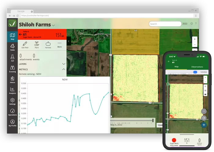
FarmQA customers with a Planet subscription were previously able to import Planet data into FarmQA using the FarmQA Map Layers functionality. With this new global partnership, FarmQA customers can license near-daily satellite imagery from FarmQA directly with no minimum purchase required. In addition, those with FarmQA Viewer access can view the imagery using the FarmQA mobile app. This extended access equips growers with an affordable way to spot crop health or other issues in near real time.
“We are pleased to offer our clients access to Planet’s global, high-cadence satellite imagery. The additional benefit for our customers is that they can select specific fields for which they want to bring in data,” says Paul Bramel, FarmQA’s vice president of engineering. “With the option to select and limit, we are able to affordably provide data-rich imagery specifically where it’s most valuable to our customers.”
Users can locate Planet Imagery through the mobile app and FarmQA’s web application. Farm QA Analytics amplifies Planet imagery when detecting the areas customers have identified. This feature can save consultants and growers’ time and crops.
“Our goal has always been to use technology to help agribusinesses not only be more efficient at what they do, but to enhance the services they provide to their growers,” says Howard Dahl, FarmQA’s CEO. “This partnership provides further proof of our commitment to listen to our customers and understand where we can continue to add the most value to their service offering.”
Having access to the right data helps informs decisions about crop management. Planet’s features serve as a learning tool for how to monitor crop development and detect crop health issues; map and direct scouting, localize treatment and optimize inputs in select areas; and create better crop plans by accessing historic crop productivity maps across multiple years.

![[Technology Corner] Farmers Gain Trust in Autonomy with PTx OutRun Retrofit Kit](https://www.precisionfarmingdealer.com/ext/resources/2026/07/09/Farmers-Gain-Trust-in-Autonomy-with-PTx-OutRun-Retrofit-Kit.webp?height=290&t=1783695127&width=400)

