TRIMBLE – Trimble RTX
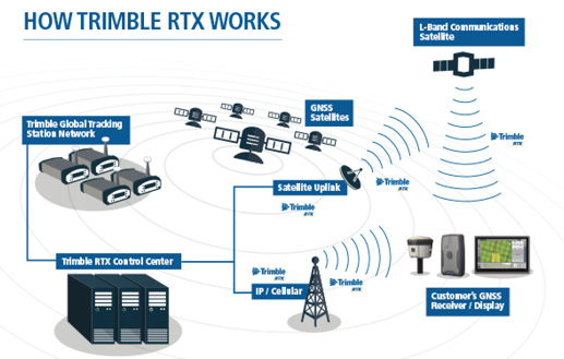
Tech Specs: Trimble RTX (Real Time eXtended) technology utilizes data from a global reference station infrastructure to compute high accuracy positions based on satellite orbit and clock information. It supports a suite of real-time correction services delivering a range of accuracies from better than 1.5 inches to sub-meter performance. The correction services accommodate a wide range of applications and accuracy requirements including CenterPoint RTX, which provides better than 1.2-inch horizontal accuracy with less than 30 minute initialization time and RangePoint RTX which provides better than 20-inch horizontal accuracy with 5 minute initialization time. CenterPoint RTX Fast provides less than 5 minute initialization time and is currently available via satellite throughout Colorado, Illinois, Indiana, Iowa, Kansas, Kentucky, Michigan, Minnesota, Missouri, Nebraska, South Dakota, Tennessee, Wisconsin and much of Manitoba and Saskatchewan. Horizontal accuracy specifications are based on in-field performance 95% of the time.

The high accuracy correction services delivered via satellite offer quick initialization, multi-constellation support, more uptime, no additional data or cellular plans needed and no base station is required. They are repeatable pass-to-pass, season-to-season and year-to-year for achieving high accuracy positioning for your guidance system.
www.Trimble.com/Positioning-Services/Agriculture
NOVATEL INC. – TerraStar Correction Services

Tech Specs: TerraStar Correction Services from NovAtel improve the position accuracy and performance of your precision agriculture steering and control systems by delivering reliable correction data to your Global Navigation Satellite System (GNSS) receiver. We offer centimeter-level TerraStar-C and sub-meter level TerraStar-L services. Our C service provides high accuracy 5 centimeter or 2 inch 95% accuracy corrections which are ideal when planting or seeding row crops. The L service is our broad accuracy of 50 centimeters or 20 inches with 95% accuracy that also provides 15 centimeter or 6 inch 95% pass-to-pass accuracy making it ideal for use in spraying, fertilizing and variable-rate application applications. The correction services are delivered over satellite to the GNSS receiver eliminating the cost and need to set up a separate base station and a radio link.
The system maintains and controls over 100 worldwide GNSS reference stations and transmits all-weather correction data over 7 geostationary communication satellites. This makes it possible for your GNSS receiver to see 2 satellite beams from anywhere on Earth and provides optimum global coverage. It also operates three redundant network control centers, and backup to front line support is available 24 hours a day, 7 days a week.

![[Technology Corner] Using Sensors to Measure Impact of ‘Soil Health Management’ Systems](https://www.precisionfarmingdealer.com/ext/resources/2026/07/24/Using-Sensors-to-Measure-Impact-of-Soil-Health-Management-Systems.webp?height=290&t=1784914811&width=400)

