Today AgDNA announced the launch of an all new automated NDVI satellite mapping solution with advanced crop health and cloud detection capability.
The precision mapping tool adds to the suite of AgDNA FMS capabilities that cover all aspects of farm, fleet and financial management for large scale commercial crop producers. By integrating NDVI into the platform users can now monitor crop health throughout the growing season and take corrective action to manage risk, lower input costs and maximize yield.
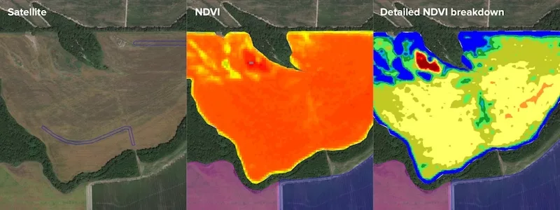
By utilizing composite Sentinel satellite imaging and advanced cloud detection technology, AgDNA can generate highly accurate vegetation health maps for all major crop types throughout the growing season. By highlighting issues within the field, growers and agronomists can save time and money by taking early action to protect crop yield in stressed regions.
The imagery can be used to create management zones and variable-rate prescriptions to ensure the optimal amount of chemical, fertilizer or growth regulator is applied depending on the health and stage of the crop.
The company’s data science team will continue to develop the satellite-based technology to deliver additional insights such as crop yield forecasting, nitrogen recommendations, irrigation optimization and more efficient crop protection strategies.
AgDNA’s integrated NDVI functionality is available now from any of AgDNA’s 400 authorized dealer locations as part of the platform’s precision subscription package.

![[Technology Corner] Farmers Gain Trust in Autonomy with PTx OutRun Retrofit Kit](https://www.precisionfarmingdealer.com/ext/resources/2026/07/09/Farmers-Gain-Trust-in-Autonomy-with-PTx-OutRun-Retrofit-Kit.webp?height=290&t=1783695127&width=400)

