
Event 38 has announced the release of its E386 Agricultural Drone Solution. By bundling its fixed-wing E386 drone with ten new apps on its cloud-based Drone Data Management System, growers now have the ability to collect detailed data and create analytics for improved farm management.
The E386-Agriculture drone has a 75-minute flight time and maps 750 acres at the 4 centimeter level in a single flight. It has been proven in the field – with experience in 60 countries.
Data captured during a flight integrates seamlessly into the company’s Drone Data Management System, its data storage, sharing and analysis platform. Data is converted into geo-referenced maps that can be viewed online, on mobile, shared, or downloaded for use in current workflows.
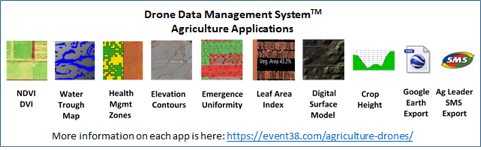
Working with growers, researchers, and industry experts over the past two years, Event 38 developed agriculture-specific apps that give growers key analytics to more effectively manage their farms:
Jeff Taylor, CEO, says, “Our goal from the beginning was to give growers and crop scouts/agronomists analytical tools to help them improve yields, save money, manage their operations more efficiently. This is just the start. We are continuing to create new applications as we get feedback from our users all over the world. We are proud to be able to offer this agricultural package and hope our customers take full advantage.”

![[Technology Corner] Farmers Gain Trust in Autonomy with PTx OutRun Retrofit Kit](https://www.precisionfarmingdealer.com/ext/resources/2026/07/09/Farmers-Gain-Trust-in-Autonomy-with-PTx-OutRun-Retrofit-Kit.webp?height=290&t=1783695127&width=400)

