Walking a field is one way to assess crop damage, insect infestation or disease. But this method isn’t always the most practical or efficient, especially for an organization with more than 200,000 farmer members.
To provide customers with an economical alternative, Richmond, Va.-based Southern States Cooperative recently launched a new aerial imagery service program, which offers customers tiered options to scout, map and analyze weak spots in the field.
Dave Swain, precision ag manager with Southern States, says the service is designed to be a “roadmap” to help farmers better identify stressed crops as a result of nutrient deficiencies, compaction issues or other limiting factors.
“What we’re seeing is because we’re being proactive in how we go to the field is that we can find problems a lot quicker,” Swain says. “Maybe they can’t be fixed right away, but we’re revealing management opportunities that the farmer can look at to solve those problems.”
While other precision dealers offer aerial imagery services, Swain says the goal of Southern States’ program is to provide flexibility for their farm customers and provide more than just a pretty picture.
The co-op’s primary offering is a three-shot program, where airplanes equipped with high-resolution cameras capture imagery at 1 meter, ½ meter and ¼ meter resolution. Initial photos are taken right when plants begin to emerge, followed by images taken 2-3 weeks later to verify crop health and any potential disease issues.
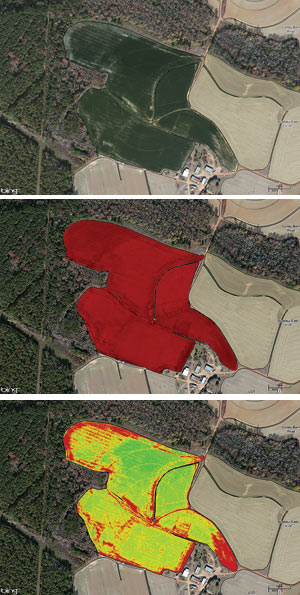
A final set of images is taken 2-3 weeks prior to tassel to allow for correction of any late-season problems that could negatively impact yield. Farmers receive a standard field image of their field, a near-infrared shot, which shows heat and reflectiveness of vegetation to assess weed infestation, and finally, a normalized difference vegetative index (NDVI) image to show potential crop health.
Swain says customers can also opt for a well-timed, single shot to identify a suspected problem in the field.
“We’ve had customers tell us that we don’t need to come out and walk their fields, because they’ve already paid for a crop consultant to scout,” he says. “What we’ll do is sell them an aerial picture, so that consultant has a better roadmap to do his or her job.
“We’re finding that some farmers and scouts may not even get that far out in the field and are not catching things and areas that can either make or lose customers a lot of money if not managed properly.”
Swain says the co-op is still refining it’s pricing plans for the aerial imagery services, but during the first year it had 4,000 acres enrolled in the program. While the vast majority of those were corn, soybeans and wheat, Swain is hoping to tap the potential of other crops such as peanuts and tobacco that are grown in several of the states served by the co-op’s precision farming operation.
“I’d like to explore crops that don’t have yield monitor capabilities to see if there is a correlation we can identify to help those farmers manage areas of their fields and assess the strong and weak spots,” Swain says. “We’ve seen some of this in cornfield shots where we could correlate the timing of the imagery back to the yield map.”
Less than a year into offering the service, Swain says the co-op is seeing early returns both as an emerging revenue source and a farm management tool for farmer members.
“We have customers who have made huge business decisions because of the imagery,” he says. “I’m talking about buying $50,000 worth of equipment because of what it showed, so it’s a big deal.”


![[Technology Corner] Using Sensors to Measure Impact of ‘Soil Health Management’ Systems](https://www.precisionfarmingdealer.com/ext/resources/2026/07/24/Using-Sensors-to-Measure-Impact-of-Soil-Health-Management-Systems.webp?height=290&t=1784914811&width=400)

