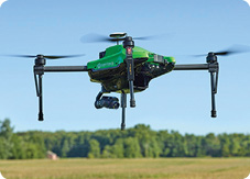
AEROVIRONMENT – Quantix Drone

Tech Specs: AeroVironment’s Quantix is a hybrid design that combines the aerodynamic efficiency of a fixed-wing aircraft with the flexibility and safety of a multi-rotor drone. It is the first hybrid drone to be introduced to the agricultural marketplace and is designed to pair seamlessly with AV DSS, allowing growers to review drone-collected data easily for both quick insights and deeper analysis. The system collects RGB and NDVI multispectral images that can be viewed on-site immediately after each flight and then are uploaded, processed and stored securely in the cloud for growers to view either on their mobile device or a desktop computer.

The AV DSS will feature a mobile app component allowing producers to collect and record infield observations. The platform is equipped with an alert system that instantly notifies farmers of anomalies in the field so that immediate action can be taken to address stressors.
SENTERA – Omni Quadcopter
Tech Specs: Sentera’s Omni quadcopter drone now has the ability to capture three distinct crop health data measurements in a single flight: thermal, normalized difference vegetation index (NDVI) and high-resolution RGB. Pairing a DJI XT Thermal sensor with the Omni’s standard Double 4K offers agronomists, crop consultants, advisors and producers a precise agriculture data capture tool that offers multi-dimensional insights. The system with DJI XT Thermal Sensor is also compatible with Sentera’s other Double 4K sensor variants, including the Multispectral Double 4K sensor. The DJI XT Thermal sensor and Sentera Double 4K sensors are available through Sentera’s extensive dealer network.
While no sensor can diagnose specific diseases in plants, the drone with thermal, NDVI and RGB data-capture capability gives ag professionals a head start detecting and diagnosing issues earlier and more efficiently.
SENSEFLY – senseFly Corridor Solution
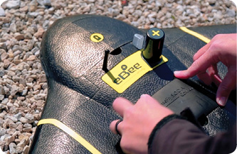
Tech Specs: Corridor mapping is a common task for many geospatial professionals and crucial for the effective planning, design and analysis of linear infrastructure, as well as the monitoring of rivers and coastlines. However, using drones to carry out corridor projects — as an alternative to hiring expensive manned aircraft — has, until now, been a relatively complex job that contained some frustrating inefficiencies. senseFly Corridor is a combined hardware and software solution, which is optimized for any eBee Plus drone that carries a S.O.D.A. photogrammetry camera. It includes: a camera integration kit, which houses the S.O.D.A. in a longitudinal (portrait) position, and a new corridor mapping ‘mission block’ within eMotion 3 ground station software.
A vertical camera position allows operators to fly the eBee Plus closer to the ground, while still achieving the image overlaps their digital outputs require. The result of flying lower is lower ground resolution, of down to 1.5 centimeters (or 0.6 inches) per pixel. Compared to using a normal, landscape-position drone camera, the system can map the same linear route using 30% fewer images. This means 30% shorter image processing times after a flight.

![[Technology Corner] Farmers Gain Trust in Autonomy with PTx OutRun Retrofit Kit](https://www.precisionfarmingdealer.com/ext/resources/2026/07/09/Farmers-Gain-Trust-in-Autonomy-with-PTx-OutRun-Retrofit-Kit.webp?height=290&t=1783695127&width=400)

