AeroVironment – Quantix Drone & AV DSS Analytics Ecosystem
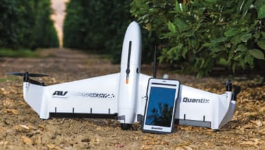
Tech Specs: Quantix drone features a simple, automated flight and a unique hybrid design that launches vertically and transitions to horizontal flight, maximizing aerodynamic efficiency and range. With the touch of a button, the system initiates a fully-automated takeoff, flight and landing, eliminating the learning curve so even first-time users can operate the drone to collect meaningful data. Operators can now survey their entire farm more efficiently and accurately, to spot crop health issues that might be missed by the naked eye. Its integrated cameras simultaneously capture both high resolution color and multispectral imagery. On-board processing delivers composite true color and NDVI maps as soon as the drone lands using QuickLook. This allows for quick, in-field assessment to catch potential issues before they start impacting yield. Collected data integrates with the AeroVironment Decision Support System (AV DSS). The system automatically performs advanced image processing, analytics, and comparative and historical reporting. AV is delivering a complete end-to-end ecosystem — hardware and software from the same company, eliminating compatibility concerns.

AV DSS Analytics Software automatically aggregates all of an operator’s data making this complete ecosystem easy to use and understand to help improve operational efficiencies and profitability.
senseFly – eBee SQ
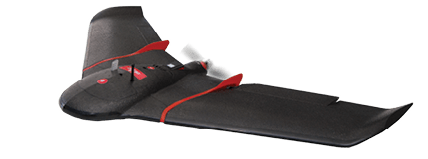
Tech Specs: The eBee SQ is an advanced agricultural drone that can fly for up to 55 minutes on a single battery charge. The system fully integrates Parrot’s Sequoia camera. This multispectral sensor captures data across four highly distinct spectral bands (near-infrared, red-edge, red and green) plus visible RGB imagery — in just one flight. Once the drone’s images have been processed, the Sequoia’s broad spectral data enables numerous vegetation indices to be computed including NDVI, Normalized Difference Red Edge (NDRE), Modified Chlorophyll Absorption in Reflectance Index (MCARI) and Canopy Chlorophyll Content Index (CCCI). The resulting index maps can then be employed to assess factors such as a plant’s chlorophyll levels, a key indicator of crop health.
The eBee SQ can cover up to 500 acres in a single flight at 400 feet above ground level — up to 10 times more ground than small quadcopter drones — for extremely efficient crop monitoring and analysis.

![[Technology Corner] Using Sensors to Measure Impact of ‘Soil Health Management’ Systems](https://www.precisionfarmingdealer.com/ext/resources/2026/07/24/Using-Sensors-to-Measure-Impact-of-Soil-Health-Management-Systems.webp?height=290&t=1784914811&width=400)

