There’s no question that the ag industry is getting ready for a real game changing shift in remote sensing largely due to the reliable Unmanned Aerial Systems on the market today. There are many discussions about what the real value of UAS will be to the grower, but honestly for the first time you can begin to see the “varsity players" breaking away in this industry as they are closing in on real solutions beyond the basic scouting solutions. These companies have systems that are currently being used daily around the world. Over the past several years, we have been able to watch them develop as the industry has really begun to take shape.
Your Starting Lineup “The Varsity Team”
DJI
In this industry, DJI has become the “brand” people most recognize with drones. With marketshare over 75%, they are the big player and for good reason. They continue to release amazing products that set the bar for entry level and pro equipment. We’ve seen the shift from DJI now to new sensors which will provide more value to ag. The new partnership with FLIR produced a new thermal camera solution combined with proven DJI gimbal to easily integrate into existing systems (Inspire 1 Platform). Streaming HD video w/ great range via your iPad screen is amazing and is standard equipment. It should honestly be a must have feature when you consider your purchase. Latest generation just released raises the bar even higher with great NEW features like: live object tracking, better flight times, object avoidance and redundant flight systems.
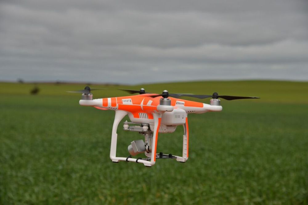
THE BEST SELLING DRONE HAS BEEN THE PHANTOM SERIES FROM DJI. PHOTO ABOVE A FLYINGAG.COM PHANTOM 3 PRO KIT PRICE FROM $1699.
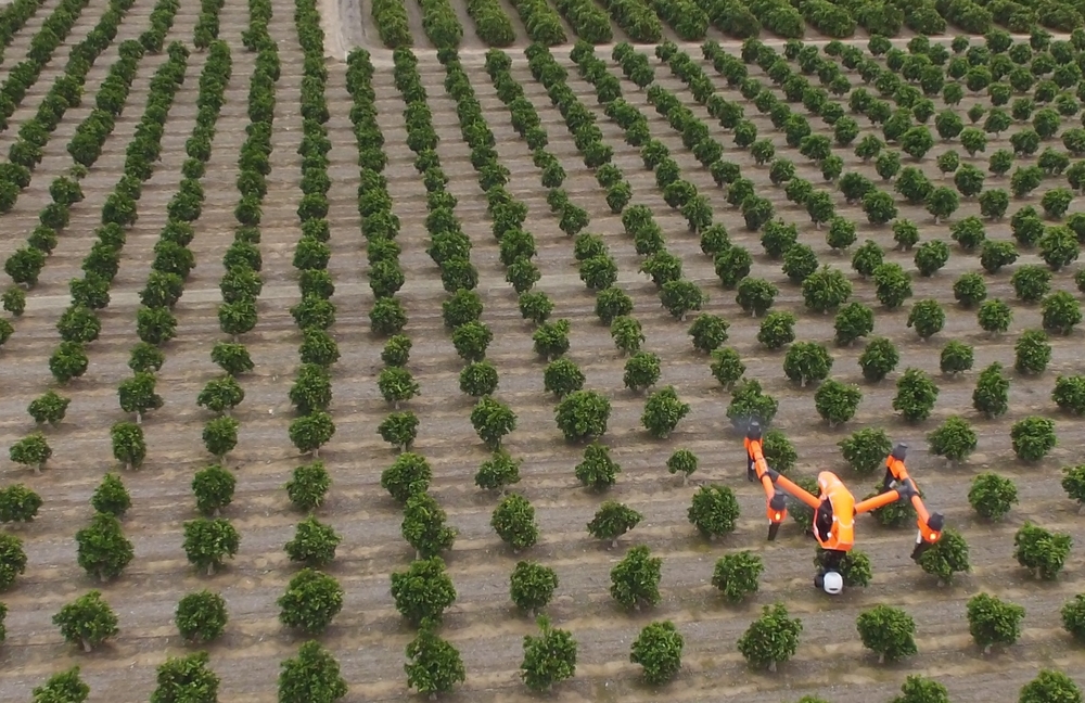
DJI INSPIRE 1 BY FLYINGAG.COM FLYING CITRUS FARM IN CENTRAL CALIFORNIA USE THE DRONEDEPLOY SYSTEM. THIS PLATFORM IS NICE LARGELY DUE TO IT'S ABILITY TO CHANGE SENSORS (LIKE FLIR SENSOR BELOW) AND LONGER FLIGHT TIMES. IT CAN FLY 160 ACRES USE THE DRONEDEPLOY SYSTEM WHICH IS PERFECT IN MY OPINION WITH CURRENT REGULATIONS (WITHIN LINE OF SITE).
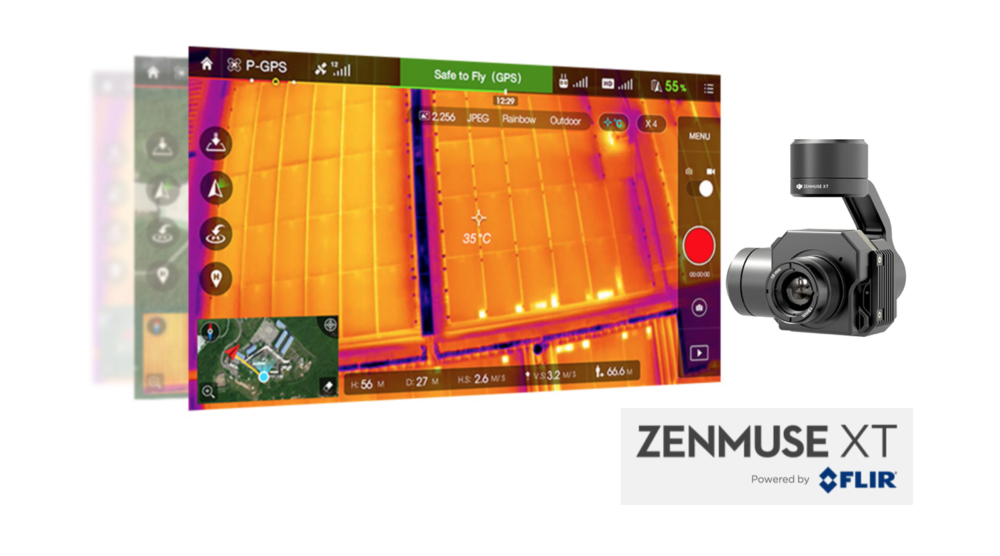
THE CAMERA ON THE DJI ZENMUSE XT IS DEVELOPED BY FLIR. IT PROVIDES HIGH-SENSITIVITY (50MK) INFRARED SCANNING AT 640/30 FPS OR 336/60 FPS DEPENDING ON THE CAMERA MODEL. STABILIZED AND CONTROLLED BY A CUSTOM DJI GIMBAL, IT PROVIDES SMOOTH, CLEAR IMAGERY AND 360 DEGREES OF SEAMLESS ROTATIONAL MOVEMENT.
DroneDeploy
Can’t say enough great things about the steps they have taken over the past year. For entry level users, they created an easy, one-step integration with DJI platforms via an application for your iPad to operation your DJI platform. The system completely controls the mission, camera and when your flight is complete it will manage your data. Honestly, it’s the best place to get started to understand the process of remote sensing. Look for more things from them in 2016. Currently, they have daily operators in over 30 countries and have proceeded well over 1 million acres around the world. They will continue to move this technology forward. Keep your eye on them.
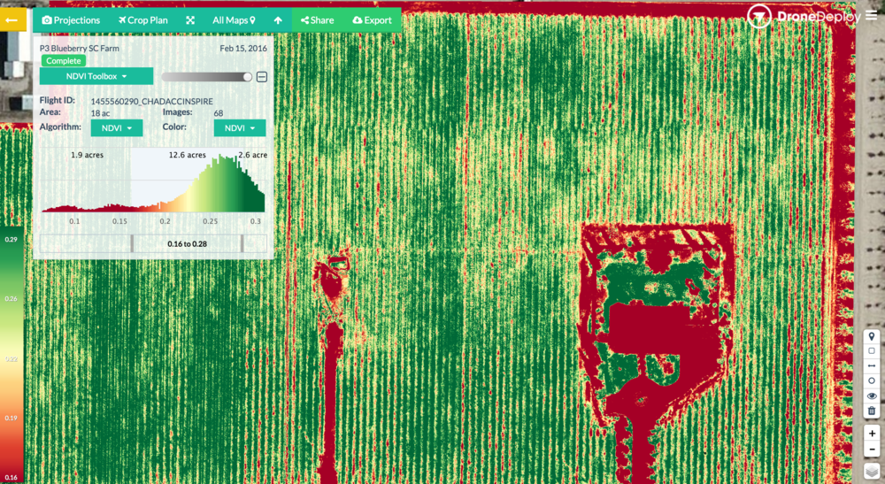
THIS IS SCREEN SHOT FROM FEB 2016 IN CENTRAL CALIFORNIA, FLOWN WITH FLYING AG'S PHANTOM 3 PRO KIT. THE DATA FROM DRONEDEPLOY HAS LOTS GREAT INFORMATION FOR THE GROWER.
senseFly
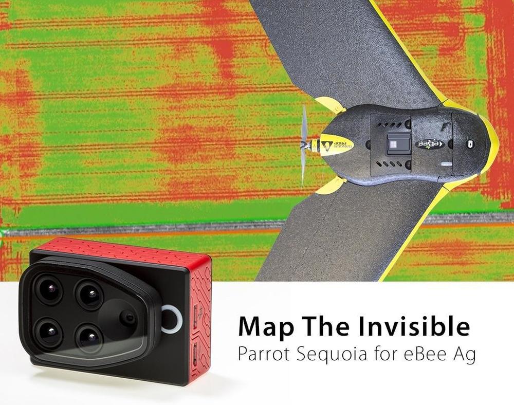
senseFly is a Parrot company and they have various platforms but the eBee fixed-wing is simply amazing. It can produce maps easily with it’s intuitive eMotion software which makes it easy to plan and perform your mission. They also host a complete infield solution if you have limited Internet service in the field. Parrot owns other companies that play a key role in the solution offering like Pix4Dmapper. For 2016 they have combined the eBee with the NEW Parrot Sequoia multispectral sensor. Sensors are beginning to really develop for UAS use and this sensor is loaded with features, 4 narrow bands, RGP, built in GPS, and incident light sensor to calibrate the data. Best part is it’s at a VERY realistic price point of $3500. Other side of this new sensor is MicaSense Atlas software which was in use last year and looked very promising.
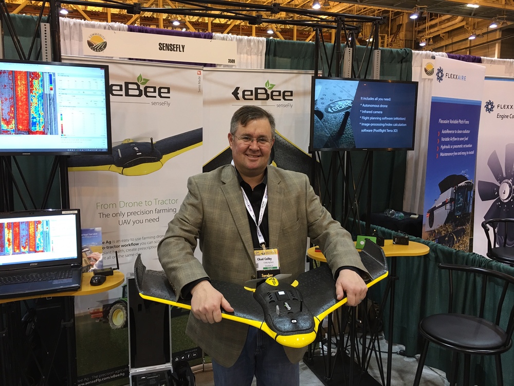
HOLDING EBEE W/ INTEGRATED PARROT SEQUOIA SENSOR AT 2016 COMMODITY CLASSIC, MARCH 2016.
THE FIX WING PLATFORM EBEE FROM SENSEFLY IS ONE OF THE MOST RECOGNIZED PLATFORMS IN THE WORLD, COMBINED WITH EMOTION SOFTWARE AND THE PARROT SEQUOIA SENSOR IT WILL BE VERY WE RECEIVED IN 2016.
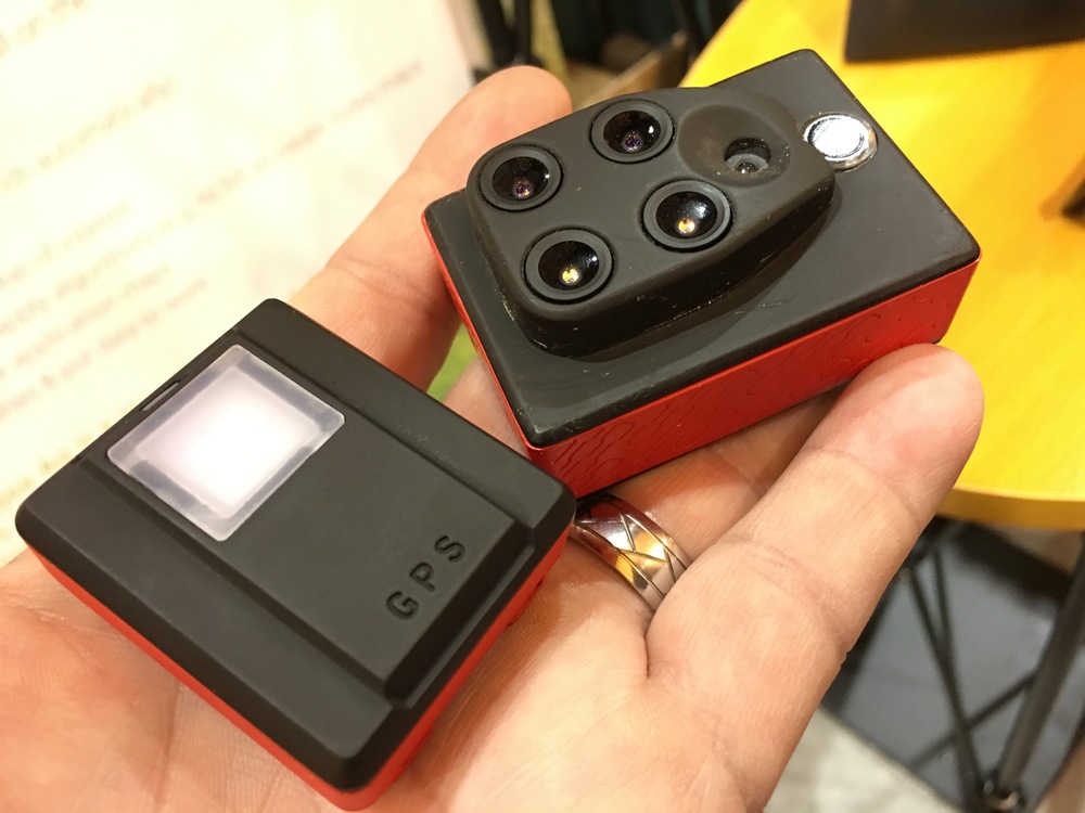
PARROT SEQUOIA MULTISPECTRAL CAMERA, WEIGHING ONLY 107 GRAMS, SEQUOIA IS A POWERFUL SENSOR IN A REMARKABLY SMALL PACKAGE. THIS CAMERA FEATURES FOUR NARROWBAND FILTERS OPTIMIZED FOR ANALYZING CROP HEALTH AND A 16 MP RGB IMAGER FOR EASY DIGITAL SCOUTING. SEQUOIA'S IRRADIANCE SENSOR AND INTEGRATED GPS MAKE IT AN ACCURATE AND CALIBRATED TOOL FOR PRECISION AGRICULTURE.
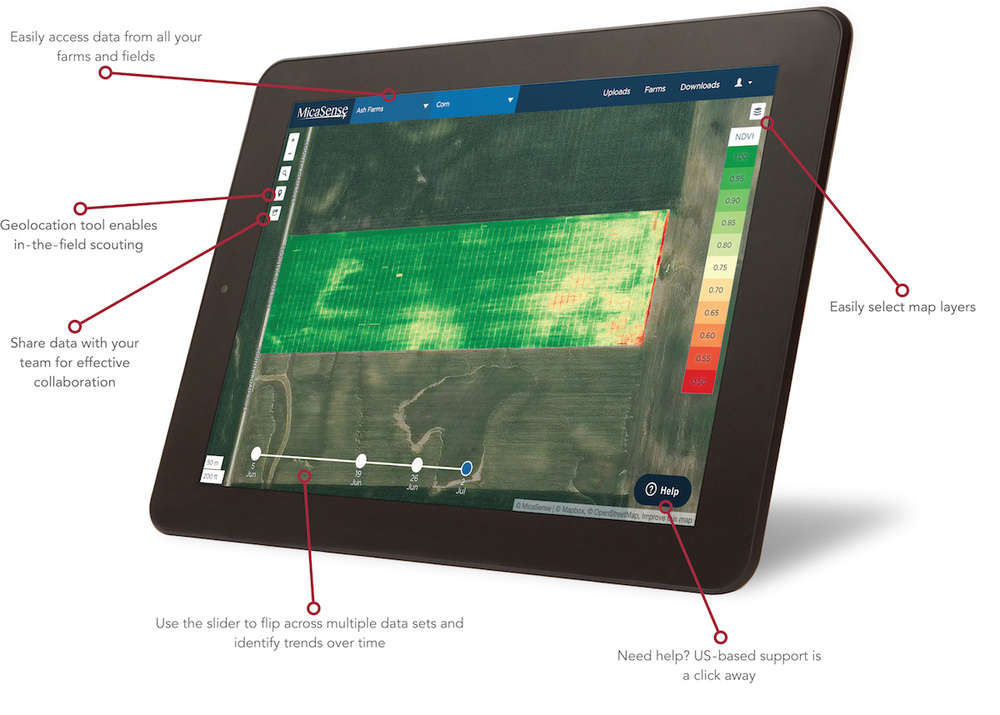
MICASENSE ATLAS™ OFFERS A POWERFUL DATA SERVICE FOR STORAGE, PROCESSING, ANALYSIS, AND PRESENTATION OF MULTISPECTRAL DATA. USING SECURE CLOUD-BASED SERVERS, YOUR RAW DATA IS PROCESSED INTO ACTIONABLE INFORMATION THAT CAN BE ACCESSED FROM ANY INTERNET-CONNECTED DEVICE.
PrecisionHawk
PrecisionHawk has been one the leading companies in the industry since it’s early beginnings years ago. They have always been known for pursing the real value from the data. Great to see them recently roll out another dimension to the information pipeline called Algorithm Marketplace. Called DataMapper, users are able to efficiently turn UAV-acquired geospatial data into actionable insights. This is the real deal, they are already working with over 60 colleges and universities around the world. Best part is this DataMapper will accept the data from any platform into it’s Algorithm Marketplace. PrecisionHawk is also developing a LATAS platform (Low Altitude Traffic and Airspace Safety) which connects leading airspace management technologies, such as sense and avoid, geofencing and aircraft tracking. Recently, they have announced an agreement with Verizon to integrate cellular into this system. A move in the right direction if you ask me.

DATAMAPPER FROM PRECISION HAWK HAS ONE OF THE BEST SUITES OF TOOL TO ANALYZE DATA THAT IS OUT THERE. UPLOAD YOUR IMAGES DIRECTLY TO THEM TO GET THE REQUIRED RESULTS.

PRECISION HAWK IS ALSO DEVELOPING LATAS (LOW ALTITUDE TRAFFIC AND AIRSPACE SAFETY) PLATFORM CONNECTS LEADING AIRSPACE MANAGEMENT TECHNOLOGIES, SUCH AS SENSE AND AVOID, GEOFENCING AND AIRCRAFT TRACKING.
More than ever, it's important to do your research. Buying products from these varsity players is just smart business. As the technology changes these products will hold their value MUCH better than anyone else. They also have the support network and funding to continue developing this technology. The fact is that many growers are moving forward cautiously with these technologies due to so many missed truths.
The trick moving forward is the actionable data, as we’ve now passed the challenge of remote control flight and now it’s all about the data. These companies mentioned above are the leaders. There are others big players in the market that make amazing equipment like: Horizon Hobby, Yunceec, 3DR, Trimble, AerialTronics, & Aeryon Labs but right now I don’t see agriculture as their mainstream of business, or at least not yet.
Needless to say, 2016 looks to bring growers around the world more remote sensor technologies and software like we have never seen before. Like many, I personally can't wait to get flying! But I'm also looking forward to watching other companies developing NEW products for ag industry.
Need information and guidance about using UAS in agriculture in the United States? Review the website www.knowbeforeyoufly.org.

![[Technology Corner] Farmers Gain Trust in Autonomy with PTx OutRun Retrofit Kit](https://www.precisionfarmingdealer.com/ext/resources/2026/07/09/Farmers-Gain-Trust-in-Autonomy-with-PTx-OutRun-Retrofit-Kit.webp?height=290&t=1783695127&width=400)

